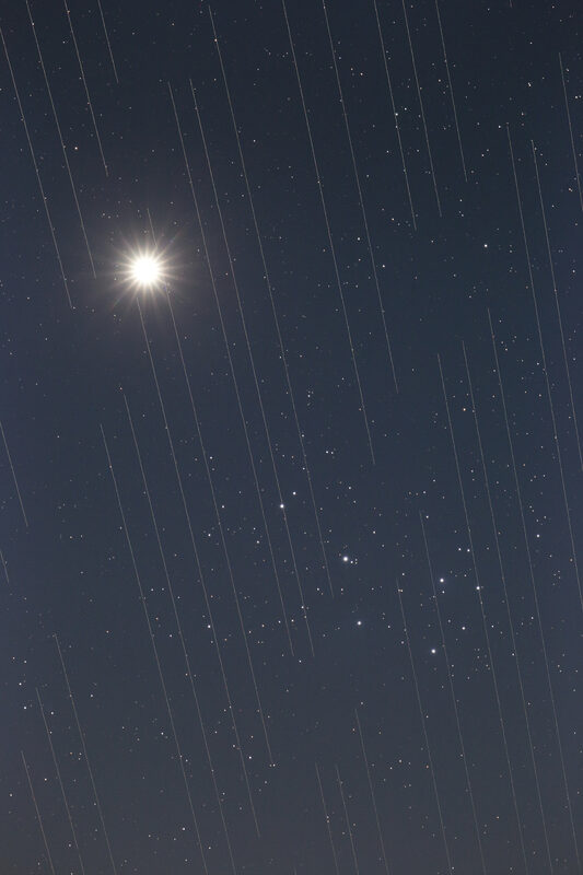
The first time Clarae Martínez photographed the same patch of sky twice in a week, twelve of her exposures had ruined stripes across them. Not atmospheric artifacts, not cosmic ray hits — satellite trails, each one a bright line drawn by a Starlink or OneWeb satellite crossing her field of view during a 300-second exposure. She works at a mid-latitude observatory doing wide-field survey work. The number of trails in her data has grown monotonically with the total number of satellites in low Earth orbit, and that number shows no sign of slowing.
As of mid-2026, roughly 7,000 SpaceX Starlink satellites are operational, alongside several hundred OneWeb broadband satellites, AST SpaceMobile's growing BlueWalker/BlueBird constellation, and China's planned Qianfan network of 14,000 satellites. The total number of active commercial satellites in low Earth orbit has roughly tripled in four years, and the regulatory approvals already granted — by the FCC, Ofcom, and ITU registration — authorize many multiples of the current population. The operational mega-constellation era is not approaching; it arrived.
The brightness problem
Astronomy's specific vulnerability is not that satellites are bright — they are not visible to the naked eye most of the time — but that modern survey telescopes take long exposures that integrate light from a moving satellite into a trail many thousands of times brighter than the faint galaxies being imaged. A single Starlink satellite at typical altitude crossing a four-minute Vera Rubin Observatory exposure generates a trail that saturates the detector, and each saturated pixel bleeds into adjacent ones, corrupting a region of the image far beyond the trail itself. The Rubin Observatory Legacy Survey of Space and Time (LSST), designed to image the entire southern sky repeatedly over ten years, was modeled before the constellation era. Current analyses suggest it will see 30 to 100 satellite trails per standard 30-second exposure during twilight hours, when most LEO satellites are illuminated by the Sun while the ground is dark.
SpaceX introduced visor sunshades on Starlink v1.5 satellites and a "dark coating" on v2 satellites. The coatings reduced the mean Starlink brightness from around 5th magnitude (borderline naked-eye) to around 6th to 7th magnitude (below naked-eye visibility for most people). For radio astronomy, this is irrelevant — the issue is electromagnetic interference in protected radio frequency bands, and both SpaceX and AST SpaceMobile have had documented instances of transmitting in bands assigned to radio telescopes. The Square Kilometre Array low-frequency component in Western Australia operates in the same frequency range as the downlink beams from some generation-2 satellites.
The regulatory gap
Satellite brightness and radio interference were historically not part of ITU spectrum coordination, because no previous satellite operator had proposed 40,000-satellite systems. The ITU framework regulates frequency use efficiently for a world of hundreds of satellites, not tens of thousands. The FCC has moved to require orbital debris mitigation plans from new constellation applicants, and in 2022 adopted new rules requiring deorbit within five years rather than the previous 25-year standard. Neither rule directly addresses brightness or aggregate interference effects.
The IAU established its Centre for the Protection of the Dark and Quiet Sky from Satellite Constellation Interference (CPS) in 2022, in partnership with the UN Office for Outer Space Affairs. The centre publishes impact assessments, maintains satellite brightness databases, and coordinates technical working groups with operators. SpaceX has engaged with these groups. Other operators have been less responsive.
What mitigation actually buys
The best-case outcome of current mitigation efforts — dark coatings, improved orbital shells, scheduling observations to avoid satellite-heavy twilight windows — is a reduction in trails-per-image by a factor of three to five. That brings Rubin from an untenable situation to a manageable one, with software masking algorithms handling the remaining contaminated pixels. For traditional narrow-field observatories, the impact is small: a single 10-arcminute field of view rarely contains a satellite at any given moment. For wide-field time-domain astronomy, citizen science astronomy, and naked-eye star visibility, the trajectory is toward a permanently changed sky.
The science proceeds. Astronomers are writing satellite-trail masking into their data pipelines, building machine learning classifiers to flag and remove contaminated images, and adjusting observation scheduling. The tools work, imperfectly. What they cannot recover is the baseline: the sky that existed before 2019, when a rocket could carry 60 satellites and deploy them in a single launch, changed the relationship between civilization and the night sky in a way that no regulation has yet reversed.