
Sea-surface height doesn't sound like the kind of number that decides whether a coastal town evacuates. But feed it into a hurricane model, and it can be exactly that. This September, NASA says two satellites orbiting 30 seconds apart are supplying that number with unusual precision, at a moment when the ocean itself has been slow to tip its hand.
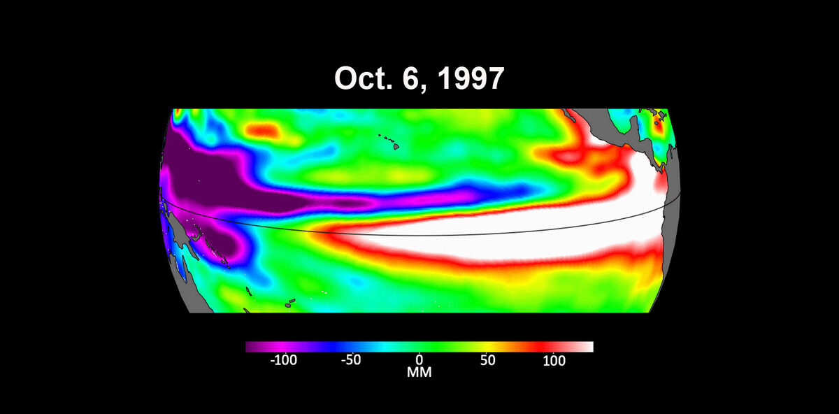
In a report published September 9, 2026, NASA/JPL described how Sentinel-6 Michael Freilich and its newer partner, Sentinel-6B, are tracking a 2026 El Niño event. The catch, according to Sentinel-6B project scientist Josh Willis, is timing. "This El Niño was a late-bloomer," Willis said. "It didn't kick off until the middle of the year and is just now reaching a strength similar to what we've seen in the satellite record during significant El Niños in 1997 and 2015. We expect it to be big, and it's already having big impacts."
Two Satellites, 30 Seconds Apart
Sentinel-6 Michael Freilich has been measuring ocean height since its 2020 launch, extending a satellite altimetry record that traces back to the TOPEX/Poseidon mission in 1992. Sentinel-6B, launched from Vandenberg Space Force Base on a SpaceX Falcon 9 in November 2025, is its near-identical twin. It returned its first sea-level imagery on December 16, 2025, according to the European Space Agency, and began delivering low-latency data to forecasters on July 15, 2026, per JPL.
For a transitional stretch, the two spacecraft are flying in tandem — trailing each other by just 30 seconds along the same orbital track. That overlap isn't a coincidence; it's a calibration strategy. Each satellite carries a Poseidon-4 radar altimeter and a microwave radiometer, bouncing radar pulses off the ocean surface to measure its height, along with wave size and marine wind speed. A second instrument, using GNSS radio-occultation, reads atmospheric humidity, pressure and temperature by watching how GPS-type satellite signals bend as they pass through the air. By having both satellites measure the same patch of ocean seconds apart, engineers can confirm that Sentinel-6B's instruments agree with Freilich's before it takes on the reference role — the designation that makes it the backbone of the long-term sea-level record.
Deputy project scientist Severine Fournier put the goal plainly: "The key is consistency, measuring the same way, every time." A four-decade climate record is only as good as its stitching, and the tandem flight is how that stitch gets checked.
Why a Late El Niño Matters for Hurricanes
El Niño — a periodic warming of the central and eastern tropical Pacific — reshapes wind patterns far beyond the Pacific itself, including the wind shear that can tear apart or protect developing hurricanes in the Atlantic. When El Niño arrives on schedule, forecasters have a full season to fold it into seasonal outlooks. A late-arriving one, at comparable strength to 1997 and 2015, complicates that lead time even as the Atlantic hurricane season is already underway.
That's where the altimetry data does its quieter, less headline-friendly work. Sea-surface height is a proxy for ocean heat content — warm water expands and literally stands taller than cool water. Warm upper-ocean layers are fuel for intensifying storms, and knowing exactly where that fuel is pooling helps forecasters catch the storms most likely to strengthen fast. NOAA oceanographer Deirdre Byrne underscored why that speed matters to the people in a storm's path: "Hurricanes have been known to speed up quickly at the last moment." A storm that intensifies rapidly in its final approach to land leaves evacuation planners far less room for error than one that strengthens gradually over days.
A Four-Agency, Two-Continent Mission
Sentinel-6 is a joint undertaking of NASA and NOAA in the United States, and ESA, EUMETSAT and the European Commission in Europe, with France's CNES also a partner. EUMETSAT, which took operational control of each satellite after launch, describes the mission as extending an altimetry record that runs from TOPEX/Poseidon (1992–2006) through the Jason series (2001–2016) to today — a nearly continuous 34-year measurement of how the ocean's surface has changed. That record currently shows a global sea-level rise trend of 3.2 millimeters per year, according to ESA.
Under the mission's plan, Sentinel-6B is set to eventually take over from Sentinel-6 Michael Freilich as the reference altimetry mission — the satellite whose measurements anchor the long-term climate record — a handoff the tandem flight and cross-calibration are designed to make seamless.
Why It Matters
Hurricane forecasting and long-term climate monitoring are often treated as separate scientific enterprises, but Sentinel-6 is built on the premise that they share the same raw material: precise, continuous measurement of the ocean's surface. The same radar altimeter reading that lets scientists track a 3.2-millimeter-a-year rise in global sea level is, day to day, also the reading that tells a hurricane forecaster where the warm water is pooling ahead of a storm. Getting the handoff between Freilich and Sentinel-6B right — flying them 30 seconds apart until their numbers are proven to match — protects both jobs at once: the decades-long climate record and the near-term forecasts that inform evacuation calls. A late-blooming El Niño of 1997-or-2015 magnitude, arriving as this handoff plays out, is as good a stress test as the mission could ask for.